Eastern Seed Zone Forum Open
 The USDA Forest Service Reforestation, Nurseries, and Genetic Resources team has been assigned the task of determining how best to develop seed zones for Region 9, the Northeastern Area, and the Southern Region. These seed zones are being developed to help the National Forest System address sustainable forest management and ecosystem restoration challenges related to climate change in a uniform manner across regional and political boundaries. These seed zones should be developed in a manner encourages their adoption by state partners, the Department of Agriculture (USDA), Department of Interior (DOI), state forestry agencies, NGOs, seed producers, land managers, and other interested groups or individuals.
A new website was developed for the Forum as a platform for information, a place to host a webinar series, and for regional groups to collaborate. The Seed Zone Forum team will review the literature supplied by top scientists, and consult with on-the-ground regional teams to develop zones that are biologically relevant, but also administratively feasible. The team invites natural resource professionals, or conservation practitioners, from public agencies (federal, state, county, etc), universities, NGOs and industries to help in this endeavor. Public webinars, forums and meetings will be held culminating in a final report to help determine the new seed zones.

![]()
National Cattle Comfort Advisor Available Now
Oklahoma Mesonet has released a National version of their popular Cattle Comfort Advisor Tool which provides up to the hour projections on cattle comfort across the United States. A webinar about this tool is available on the USDA-NIFA Funded Great Plains Grazing Coordinated Agricultural Project (Grazing CAP) website.
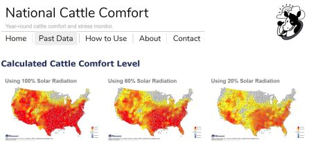
From Mesonet: “The Oklahoma Mesonet has expanded its Oklahoma Cattle Comfort Advisor to a national tool with the launch of the National Cattle Comfort Advisor. National cattle heat/cold stress maps are updated hourly and archived back to January 1, 2016. These national stress maps help cattle producers: monitor stress conditions using local environmental conditions, guide cattle water demand decisions, track weather changes that increase cattle health risk, track stress over multiple days, monitor severity of extreme weather events, monitor when to avoid working cattle, and know when transported cattle came from an area with weather stress. With no national database of solar radiation, the National Cattle Comfort Advisor calculates heat/cold stress at 100%, 60%, and 20% sunlight levels each hour. Users select the sunlight level map that best fits their local conditions. There are also national maps of 1.5 meter air temperature, 2 meter relative humidity, 2 meter wind speed estimated from 10 meter wind speed data, and estimated solar radiation in watts per meter squared for each sunlight level. The National Cattle Comfort Advisor is based on the ‘Comprehensive Climate Index’ formula for livestock stress from Mader et. al. 2010. Air temperature, relative humidity, and wind data are from National Weather Service METAR dataset.”

![]()
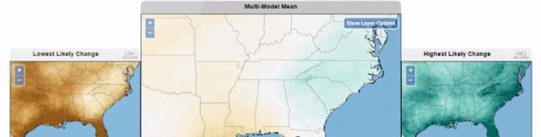
Pacific Northwest Forest Seedlot Selection Tool Released


![]()
CLN/ANREP-CSI Webinar: The Extension Sustainability Database – Connect with your colleagues on a National level
Are you interested in leading an Extension sustainability-focused program, but not sure what topics are already being covered? Do you want to learn who else is programming in this area so that you can glean experience from or collaborate with them? Perhaps you already are leading a program but may be feeling alone in your efforts. With the help of a new national database of sustainability-focused Extension programs, connecting or getting inspired is made easy! The database includes over 170 entries with 41 states represented. This webinar will walk participants through how to access and use the database, and dive in depth into some great examples of sustainability-focused Extension programs across the US.
Presented by Roslynn G.H. Brain McCann
 Dr. Roslynn Brain McCann is a Sustainable Communities Extension Specialist in the Department of Environment and Society, College of Natural Resources at Utah State University. She uses conservation theory, communication techniques, and social marketing tools to foster environmental behaviors in the areas of land (conservation, reducing, reusing and recycling), air (quality and climate change), food (consuming locally with a focus on CSA’s and farmer’s markets), water (quality, quantity, water resilient landscaping), and energy (efficiency and renewable energy). Roslynn also teaches communicating sustainability, chairs the National Network for Sustainable Living Education, helps facilitate the National Extension Sustainability Summit, runs a national database of sustainability-focused Extension programs, and is the coordinator for Utah Farm-Chef-Fork, the USU Permaculture Initiative, and Sustainable You! kids’ camps.

![]()
PINEMAP hosts Pine Plantation Research & Decision Support Tool Rollout

![]()